On Friday, January 31st, and Saturday, February 1st beginning at 10:00 AM and continuing through 2:00 PM, the City of Ashland and Grayback Forestry will manage a controlled burn to consume burn piles on City-owned forest lands just south of Lithia Park, the swimming reservoir, and the 2060 road to White Rabbit Trailhead.
Smoke from the burn will affect trails including Bandersnatch, BTI, Alice in Wonderland, Red Queen, Jabberwocky, and Snark. We recommend you avoid these trails due to brief delays for burning next to trails and for overall smoke exposure.
Opt-in for Non-Emergency Controlled Burn and Smoke Advisory Messages: Text WATERSHED in the message line to 888777.
Predicted Smoke Impacts High: Smoke will likely impact areas surrounding Lithia Park, Terrace St, Morton St, Waterline Rd, and adjacent neighborhoods. All trails in the burn area will be affected by dense smoke at times. Physical activity is not recommended when smoke is dense. Please avoid the burn area and trails impacted by smoke.
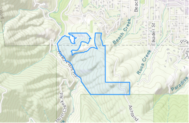
Location of Controlled Burn | City Forest Lands in the lower Ashland Watershed. See the map below. |
Date of Controlled Burn | Friday, January 31st and Saturday, February 1st from 10:00 AM to 2:00 PM |
Potential Smoke Impacts | Neighborhoods above SOU over to Lithia Park may have smoke impacts. Smoke could be visible from different parts of town and from the I-5 freeway. Trails in the immediate area will be impacted most heavily. |
What to do if smoke is in the air | The City’s Smokewise Ashland site has all the resources you need to stay healthy. |
More information | www.smokewiseashland.org |
Where is the Controlled Burn?
See the burn location on the map below.
Why Burn?
For time immemorial Indigenous peoples used fire as a land management tool and research has shown that burning accumulated fuel is an important step to restore forest resilience and reduces severe summer wildfires in our municipal watershed and community. Our primary objective when using prescribed fire is the safety and well-being of our community and fire crews. Learn more about how proactive fire planning is used to prioritize our work and guide summer fire response. The City of Ashland works in partnership across city forest lands, with private landowners and on public land for improving community wildfire risk reduction.
Stay Informed with Non- Emergency Smoke and Controlled Burning Notifications: Controlled burns will continue throughout spring and several burn locations are close to town. Smoke is expected to impact recreation trails and the community. Text WATERSHED in the message line to 888777 for non-emergency text notifications about City of Ashland controlled burns, smoke, forest management activities and events for community risk reduction.