3/5/2025 at 8:30 a.m.
UPDATE : Smoke from controlled burning may impact parts of town today including trails near the burn in Siskiyou Mountain Park around Mike Uhtoff, Queen of Hearts and White Rabbit Trails. Thank you for your patience with smoke as we reduce fuels near the community before summer wildfire season begins. The controlled burn will be in same location as yesterday, however, smoke may have a larger impact on the community. Please visit SmokewiseAshland.org for health tips.
ORIGINAL: Today, March 5, beginning at 10 a.m. and continue through 2 p.m., the City of Ashland and Lomakatsi Restoration Project will continue to manage a controlled burn to consume burn piles on City-owned forest lands in Siskiyou Mountain Park. If weather conditions allow, burning is also planned for tomorrow. This controlled burn is a phase of the Ashland Forestland Climate Adaptation Project that is managed by the City of Ashland and Ashland Parks and Recreation.
Smoke from the burn will affect trails near the burn including the upper Mike Uhtoff, White Rabbit, and Queen of Hearts trails. We recommend you avoid these trails due to brief delays for burning next to trails and for overall smoke exposure.
Opt-in for Non-Emergency Controlled Burn and Smoke Advisory Messages: Text WATERSHED in the message line to 888777.
Predicted Smoke Impacts High: Smoke will likely impact areas surrounding Siskiyou Mountain Park, Walker Street and adjacent neighborhoods around SOU and the high school. All trails in the burn area will be affected by dense smoke at times. Physical activity is not recommended when smoke is dense. Please avoid the burn area and trails impacted by smoke.
Location of Controlled Burn
| City Forest Lands in Siskiyou Mountain Park. See the map below.
|
Date(s) of Controlled Burns
| Tuesday, March 4 from 10 a.m. to 2 p.m. Burning will continue Wednesday, March 5 if conditions allow.
|
Potential Smoke Impacts
| Neighborhoods above SOU (Southern Oregon University) and around the high school may have smoke impacts. Smoke could be visible from different parts of town and from the I-5 freeway. Trails in the immediate area will be impacted most heavily.
|
What to do if smoke is in the air
| The City’s Smokewise Ashland site has all the resources you need to stay healthy.
|
More information
| smokewiseashland.org
|
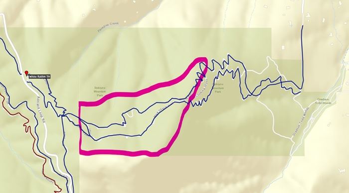
Where is the Controlled Burn?
Please avoid trails inside the pink outline in the map below due to potentially heavy smoke and workers in the area.
Why Burn?
For time immemorial Indigenous peoples used fire as a land management tool and research has shown that burning accumulated fuel is an important step to restore forest resilience and reduces severe summer wildfires in our municipal watershed and community. Our primary objective when using prescribed fire is the safety and well-being of our community and fire crews. Learn more about how proactive fire planning is used to prioritize our work and guide summer fire response. The City of Ashland works in partnership across city forest lands, with private landowners and on public land for improving community wildfire risk reduction.
Stay Informed with Non- Emergency Smoke and Controlled Burning Notifications
Controlled burns will continue throughout spring and several burn locations are close to town. Smoke is expected to impact recreation trails and the community. Text WATERSHED in the message line to 888777 for non-emergency text notifications about City of Ashland controlled burns, smoke, forest management activities and events for community risk reduction.